


وصف لـ Satellite Weather - Infrared, Water Vapor, Visible
View current weather satellite imagery loops from the NASA Geostationary Operational Environmental Satellite (GOES).
This app includes recent infrared, water vapor, and visible imagery.
See fronts, tropical storms, and hurricanes develop before they arrive.
New images come once every 15-minutes and are added onto the end of the animations automatically.
Please scroll the images side-to-side to see everything available once the animation loads.
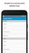
Currently available imagery loops:
1. East - CONUS (Continental United States)
2. East - North Hemisphere
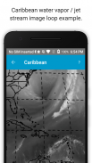
3. East - Caribbean and West Atlantic Hurricane Region
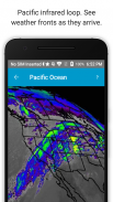
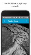
4. West - Pacific Ocean
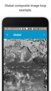
5. Global Weather Satellite Composite (note: non-North/South American data is only available once every six hours, due to international agreement).
For infrared maps, gray represents relatively warm temperatures, blues cooler, and red indicates clouds that are the coldest, tallest, and most likely to produce rain.
Image timestamps are displayed in UTC.
This app is not affiliated with NASA.
This app contains banner ads from Google on the bottom of its content. Your location is never shared with Google. For information about how to further limit ad tracking, view the app's Privacy Policy.</br></br></br></br></br></br></br></br></br></br></br></br></br></br></br></br></br></br></br></br></br></br></br></br>
Satellite Weather - Infrared, Water Vapor, Visible - إصدار 1.5
(10-06-2023)Satellite Weather - Infrared, Water Vapor, Visible - معلومات APK
نُسخة APK: 1.5الحزمة: david.gross.satellite.weather.radarتطبيقات من الفئة نفسها
قد يعجبك أيضًا...


